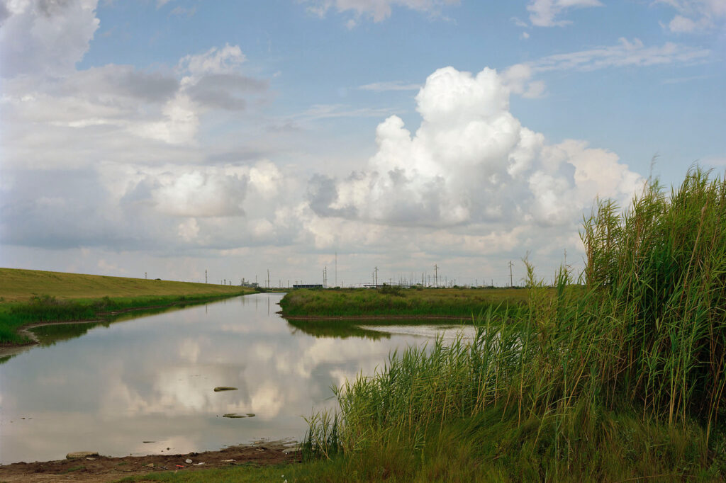
Paul Shambroom visualises the invisible landscapes of the US oil reserve
Dr Thom Davies, Research Fellow at the Department of Sociology, University of Warwick @ThomDavies
In his artistic statement quoted below, photographer Paul Shambroom asks: ‘How does one photograph something that can’t be seen?’ This is a fundamental question at the heart of all the projects in this ‘Toxic Visions’ Special Issue of Toxic News. Often the materiality of pollution is too minute to be captured by a camera; too huge to be placed inside one frame; or too complex to be reducible to image alone. Simply put, photographing pollution can be a conversation with the invisible. Despite this challenge, Shambroom has photographed many different toxic issues, from the industrial floors of factories, to nuclear weapons repositories; and from hazmat suited officials, to clinical laboratories.
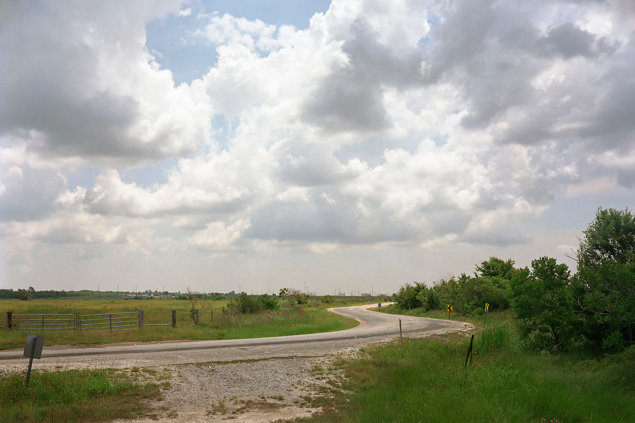
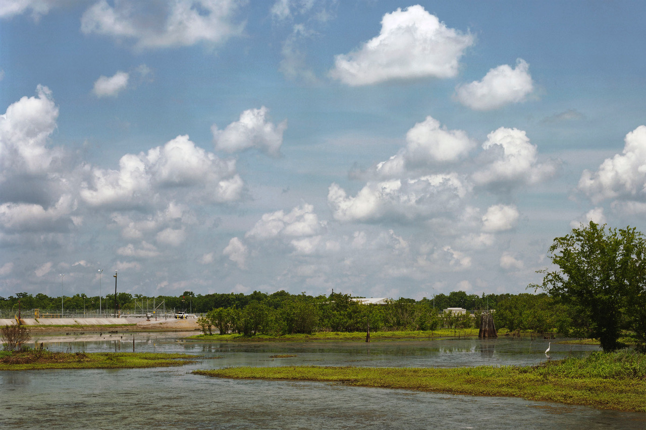
Shambroom’s project ‘Treasure: Landscapes of the U.S. Strategic Petroleum Reserve’ is a great example of what Susan Sontag meant when she said ‘There’s nothing wrong with standing back and thinking.’ In this series of four photographs, Shambroom literally stands back, using the distance between himself and his subject to realise the enormity and secrecy of the Strategic Petroleum Reserve. Though the focus of his attention, the industrial infrastructure captured in his images plays second fiddle to the natural landscape in which it sits.
His work also involved a lot of contemplation. As he explains below, he was inspired by Dutch landscape paintings ‘whose fluffy clouds and bucolic countryside spoke of that nation’s prosperity.‘ Although vital to American global military prosperity, the strategic petroleum reserve captured by Shambroom are highly restricted spaces: industrial zones that support a certain version of prosperity and hegemony, but remain just out of reach.
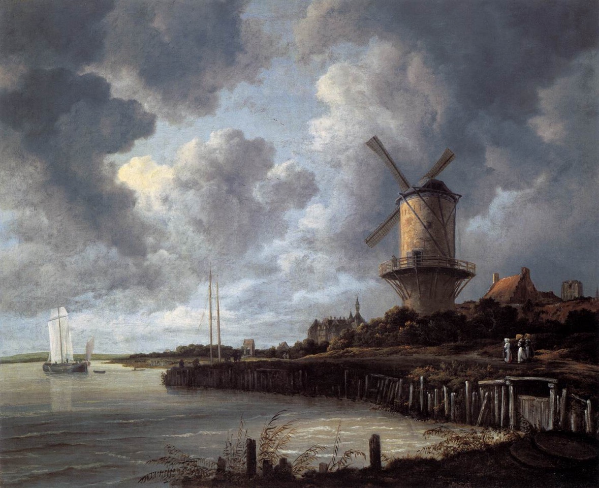
The inspiration Shambroom took from landscape paintings, such as Jacob van Ruisdael’s masterpiece from the Dutch Golden Age, reminds me of other work that has used paintings of the past to inspire contemporary explorations of pollution. For example, geographer John Thornes interpreted Claude Monet’s London Series (1899–1905) to estimate air pollution at the turn of the 20th century. As he explains in this article, these paintings present ‘a remarkable visual record of London’s climate and air quality at that time.’ Monet was very aware that the images of London’s infamous ‘pea soup‘ could fetch good money from tourists, but his artistic observations have also been valuable to geographers today who are researching the climate of the past.
Although the subterranean strategic reserves that Shambroom pictures contain enough volume to house entire skyscrapers, the landscapes he photographs often do not appear on maps. As he explains, ‘the government goes to great lengths to discourage attention.’ The sense of dislocation that these images create are executed by their captions, which portray the massive volumes of oil that are in the picture, yet out of sight : “222.1 million barrels, West Hackberry, Louisiana” The tension between the subject of the photographs and its invisibility inherent invisibility reminds me of Edward Thompson’s series ‘The Red Forest’ where he documents invisible radiation in Chernobyl.
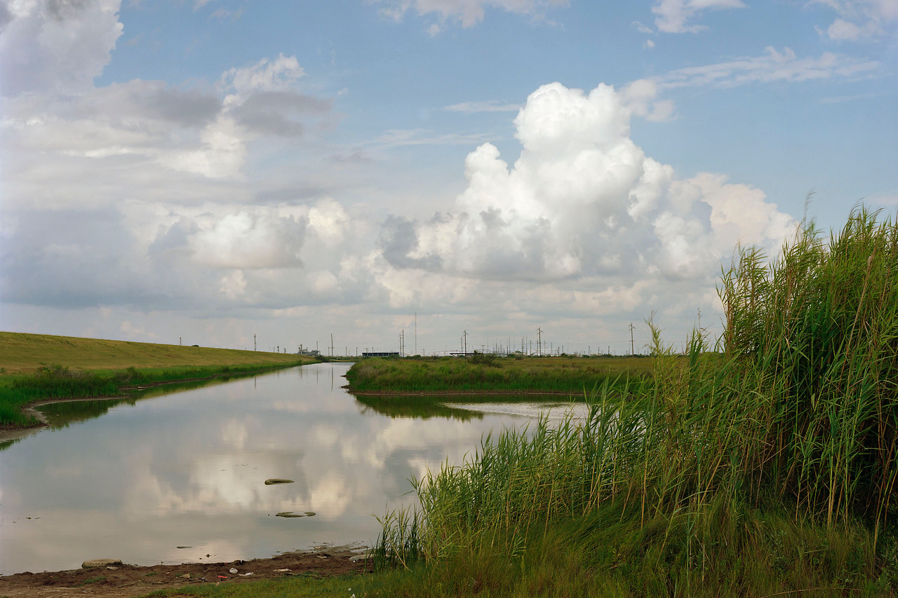
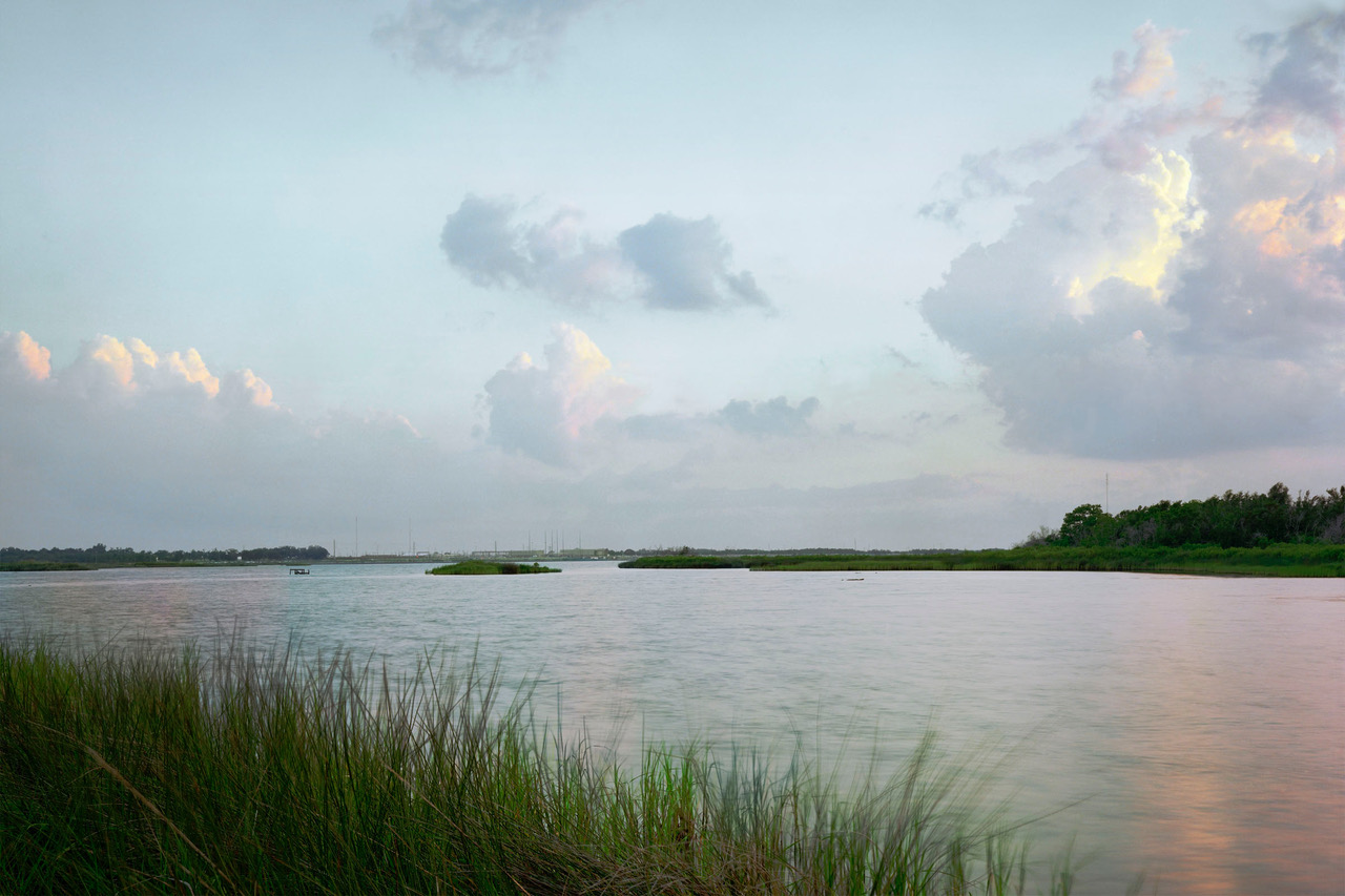
Paul Shambroom’s statement about the project can be read below. Please note that he wrote these words in 2008 and they do not reflect changes in the current environmental, political or economic situations involving the U.S:
Treasure: Landscapes of the U.S. Strategic Petroleum Reserve
The U.S. Strategic Petroleum Reserve (SPR) consists of 700 million barrels of crude oil in underground storage facilities along the Gulf coast of Texas and Louisiana. It was created after the 1973 Arab oil embargo to lessen the impact of future disruptions of America’s foreign oil supply. The sites are built on naturally occurring salt domes. The oil is stored below ground in multiple caverns formed by injecting massive quantities of water into the salt. Each cavern is approximately 200 feet wide and 2000 feet deep, large enough to contain the Sears Tower. Oil is transported in and out of the sites by buried pipelines connected to the region’s extensive petroleum industry infrastructure. The Energy Policy Act of 2005 directed that the Reserve be expanded to a capacity of one billion barrels. This will be done by enlarging three existing sites and adding an additional one in Mississippi.
There is very little to see above ground at the SPR sites- pipes, some tanks, a few buildings for maintenance, administration and security personnel and equipment. The oil below the surface is essentially invisible, as there is no human access inside the caverns. Still, the government goes to great lengths to discourage attention. These sites are designated as “critical assets” and protected by heavily armed private guards. Location maps have been removed from the Department of Energy Web site since 9/11, although aerial photos and coordinates are still available at watchdog Web sites and even on Google Earth.
To the best of my knowledge it is completely legal in the United States to photograph anything that can be seen from public land and roads (with just a few exceptions for certain military and nuclear power installations). Neither the Patriot Act nor any other post-9/11 legislation has changed this. Nevertheless, since 9/11 many photographers attempting to photograph government buildings and installations, as well as industrial and transportation sites, have been harassed, detained, and had cameras, film and memory cards confiscated by police and private security officers. The Department of Energy did agree to let me photograph from outside the sites without hindrance and allowed me to visit inside one site, but only after lengthy negotiations.
How does one photograph something that can’t be seen? My approach was to work from a distance to incorporate the land and water over the storage caverns, and include lots of sky. I took inspiration from 17th century Dutch landscape paintings, whose fluffy clouds and bucolic countryside spoke of that nation’s prosperity. For a while back in the twentieth century the United States enjoyed similar prosperity, with a seemingly limitless supply of petroleum to power industry and automobiles. The oil supply was truly “out of sight, out of mind”.
Today it is very much on our minds. The hundreds of millions of barrels of oil beneath these idyllic landscapes offer a very thin veneer of protection to our economy and way of life. By government estimates, the Strategic Petroleum Reserve could replace foreign oil imports for 59 days. Then the tap would be empty.
– Paul Shambroom (2008)
Many thanks to Paul Shambroom for letting me discuss his work. You can view his website here and the original project here.
Other articles in this Special Issue:
- Editorial: Toxic Visions – Photography and Pollution
- Exposing a Chemical Company
- The Red Forest: Picturing Radiation with Infrared Film
- Disposable Citizens: viewing Chernobyl through the lens of those live there
- The derelict afterlives of para-nuclear waste
- Rare Earthenware: photography, pottery, and pollution
- Graveyard of Giants: the Toxic Afterlives of Ships
- Voyage on the planet: contemplating pollution with Chih Chiu
- Toxic Expertise Annual Workshop 2018
References:
Susan, S., 2003. Regarding the Pain of Others. New York: Farrar, Straus, and Giroux.
Thornes, J.E., 2008. Cultural climatology and the representation of sky, atmosphere, weather and climate in selected art works of Constable, Monet and Eliasson.Geoforum, 39(2), pp.570-580.
